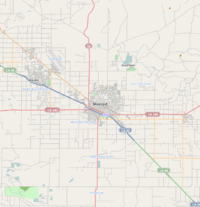
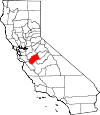
Merced, California
| City of Merced | |||
|---|---|---|---|
| — City — | |||
|
|||
 |
|||
| Coordinates: | |||
| Country | |||
| State | |||
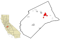
| County | Merced County | ||
| Incorporated | 1889 | ||
| Government | |||
| - Type | Council-Manager | ||
| - Mayor | Bill Spriggs | ||
| - Senate | Jeff Denham (R) | ||
| - Assembly | Cathleen Galgiani (D) | ||
| - U. S. Congress | Dennis A. Cardoza (D) | ||
| Area | |||
| - Total | 19.9 sq mi (51.4 km2) | ||
| - Land | 19.9 sq mi (51.4 km2) | ||
| - Water | 0 sq mi (0 km2) 0% | ||
| Elevation[1] | 171 ft (52 m) | ||
| Population (2007) | |||
| - Total | 80,608 | ||
| - Density | 3,216.7/sq mi (1,242.2/km2) | ||
| Time zone | Pacific (PST) (UTC-8) | ||
| - Summer (DST) | Pacific (PDT) (UTC-7) | ||
| ZIP code | 95340-95344, 95348 | ||
| Area code(s) | 209 | ||
| FIPS code | 06-46898 | ||
| GNIS feature ID | 1659751 | ||
| Website | http://www.cityofmerced.org | ||

Merced /mərˈsɛd/ is the county seat of Merced County, California in the San Joaquin Valley of Central California. As of 2007, the city had a total population of 80,608.[2] Incorporated in 1889, Merced is a charter city that operates under a council-manager government. It is named after the Merced River, which flows nearby.
Merced, known as the "Gateway to Yosemite", is less than two hours by automobile from Yosemite National Park to the east and Monterey Bay, the Pacific Ocean, and several beaches to the west. The community is served by the rail passenger service Amtrak, a major airline through Merced Regional Airport, and three bus lines. It is approximately 110 miles from Sacramento, 130 miles from San Francisco, and 270 miles from Los Angeles.
In 2005, the city became home to the tenth University of California campus, University of California, Merced (UCM), the first research university built in the U.S. in the 21st century.[3]
Contents |
Community
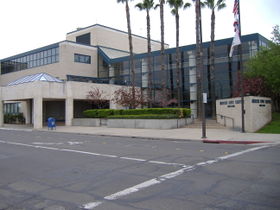
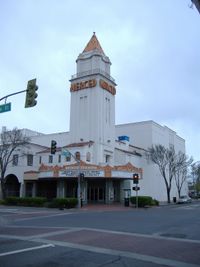
Merced is home to University of California, Merced. Current recreational opportunities in the city include Applegate Park and zoo, Bear and Black Rascal Creeks and their bike trails, a skate park located in Applegate, a live stage theater downtown, two first run movie theaters, The Mainzer Theater which is known for its historic and architectural value, County Courthouse Museum circa 1889, the Merced Multicultural Arts Center and the County Library. Though still growing, Merced has several shopping areas including the Merced Mall, anchored by Target, Sears, JCPenney and Kohl's, a strip mall located on the city's northwest side which includes Best Buy, Barnes & Noble, Lowe's, Wal-Mart, and several restaurants. Merced's Main Street contains several restaurants, a movie theater, and other assorted shops.
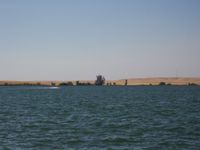
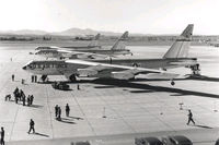
Also within a short distance from the city limits are the Castle Air Museum, Challenger Learning Center, Castle Science and Technology Museum, Lake Yosemite, and Merced Falls. Merced is also the headquarters of Malibu Boats, a manufacturer of inboard boats. The city of Merced along with its surrounding cities are serviced by the Merced Sun-Star and the Merced County Times. The Sun-Star daily newspaper has a circulation of over 20,000 in the Merced area and the Times weekly newspaper has a circulation of over 5,000.
Homes at the median level in Merced have lost 62% of their value from the second quarter of 2006, when they peaked at $336,743, the biggest drop anywhere in the country, according to data provided to Forbes by Local Market Monitor, a Cary, North Carolina-based real estate research firm. Earlier, home building and buying grew exponentially in Merced, but the metro now suffers from a 19.8% unemployment rate, according to a recent article in USA Today.[4]
In the 2007 version of the book "Cities Ranked & Rated" by authors Bert Sperling and Peter Sander, Merced was ranked 370th of 373 cities nationwide. The factors that determined the ranking of the cities within the book include the quality of life, cost of living in the area, availability and type of jobs, education, health care, climate, crime, commute times, and leisure activities.[5] However, the entry in the book also states that the town may not stay in this place for long, since the authors stated that "Merced is definitely on an upward path and offers potential not found in other Valley towns. This potential is clearly not shown in today's numbers."[5]
Merced has suffered one of the greatest property price collapses in the country and house prices at the end of 2009 had returned to 1998 levels, according to Zillow, making housing affordable compared to many other California locations. Currently the most undervalued market is Las Vegas, where homes sell for 41.4% below fair market, followed by Vero Beach, Fla. (-39.8%), Merced, Calif. (-37.7%), and Cape Coral, Fla. (-36.8%).
History
Merced was incorporated in 1889 and operates under the Council-Manager form of government. Merced's population has grown faster than the state average since 1980. Over the past nine years, the annualized growth rate is about 3.4%. This rapid expansion of population has stimulated significant retail growth since 1992. Several major retail chain stores have entered Merced, adding over 750,000 square feet of new retail space in that time and increasing the City's sales tax receipts by over $500,000 annually.
The economy has traditionally relied upon agribusiness and upon the presence of Castle Air Force Base. Over the past twenty years, more diversified industry has entered the area, including printing, fiberglass boat building, warehousing and distribution, and packaging industries.
In September 1995, Castle Air Force Base closed after phasing down over the previous three years. This has affected residential real estate and some sectors of the retail and service economies, but overall retail has continued to increase. No significant increase in unemployment has been noted. Re-use of the former base is actively proceeding. Industrial development is increasing in the area.
Since 1992, more than 400,000 square feet of new industrial activity has started. In May 1995, Merced was selected as the home of the next University of California campus. UC Merced opened with its first 1,000 students in September 2005. Local planning is underway to accommodate campus development, will eventually accommodate about 25,000 students.
The first post office opened in 1870.[6] Merced incorporated in 1889.[6] During World War Two, the Merced County fairgrounds was the site of a temporary civilian assembly center for Japanese internment.
Transportation
Major highways
 State Route 59
 State Route 99
 State Route 140
Air
- Merced Regional Airport. Passenger service provided by Great Lakes Airlines.
- Castle Airport in nearby Atwater, California.
Bus
- Greyhound serves Merced.
- YARTS provides scheduled service into Yosemite National Park.
- Merced County Transit, "The Bus", operates both regularly scheduled fixed route bus service and Dial-A-Ride (demand response) transportation services throughout Merced County.
- Cattracks is UCM's bus service, which connects students, staff and faculty at the university to off-campus apartments, the off-campus Castle facilities, local amenities, the Amtrak station, and the downtown area.
Rail
- Amtrak San Joaquin provides passenger service.[7]
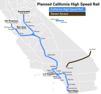
California High-Speed Rail
Officials of the California High-Speed Rail Authority say a flat, straight stretch through the San Joaquin Valley connecting Merced and Bakersfield will likely be the first completed. Regional Manager Thomas Tracy told the Visalia City Council March 2 that the 800-mile project will be built in eight phases. The first segment, due by 2015, would stretch from Bakersfield to Merced on an initial run from San Diego to Sacramento. At its full 220 mph speed, the normally three-hour car trip from Merced to Bakersfield would take 45 minutes.
Sample trips in the California High Speed rail would include:
- Merced to Sacramento - 43 minutes
- Merced to San Jose - 45 minutes
- Merced to San Francisco - 1 hour and 15 minutes
- Merced to Los Angeles - 1 hour and 40 minutes
Climate
Merced has wet, cool winters and hot, dry summers. Although thunderstorms may linger into the valley during the summer, they are normally dry. Average January temperatures are a maximum of 55.0°F and a minimum of 36.0°F. Average July temperatures are a maximum of 97.1°F and a minimum of 60.9°F. There are an average of 98.7 days with highs of 90°F (32°C) or higher and an average of 33.6 days with lows of 32°F (0°C) or lower. The record highest temperature of 114°F was recorded on July 24, 1902, and August 8, 1905. The record lowest temperature of 13°F was recorded on January 13, 2007.
Most of the rainfall occurs during the winter and averages 12.21 inches annually. There are an average of 48 days annually with measurable precipitation. The wettest year was 1998 with 21.66 inches and the driest year was 1947 with 5.50 inches. The most rainfall in one month was 8.00 inches in January 1909. The most rainfall in 24 hours was 2.20 inches, which occurred on January 30, 1911, and March 9, 1911. Although snow is relatively rare in Merced, averaging only 0.6 inch annually, the city's proximity to the Sierra Nevada has resulted in some instances of remarkably heavy snowfall. The record 24 hour snowfall was 13.9 inches on February 16, 1946. The most snowfall in one month was 39.0 inches in December 1906.[8]
Geography and geology
Merced is located at .[1] According to the United States Census Bureau, the city has a total area of 19.9 square miles (51.4 km²).
A major groundwater plume containing the contaminant PCE was discovered in Merced in the year 1987.[9] Subsequently drilling of new water wells was severely restricted.[10]
Education
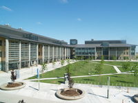
The Merced area has access to several institutions of higher learning. Within a one-hour radius, close to 100,000 students attend colleges and universities, including: University of California, Merced, California State University, Stanislaus, California State University, Fresno and the University of the Pacific. Schools of Engineering, Business, and Computer Science are readily at hand. The University of California, Merced campus opened in late 2005 northeast of the city limits. UC Merced for the 2009 academic year has an enrollment of about 3,400 students. Merced is served by the Merced Union High School District and two major public high school campuses, Merced High School and Golden Valley High School, as well as a few smaller campuses offering alternative education. Merced has one community college, Merced College, which has an enrollment of more than 10,000 full-time equivalent students (FTES).
In May 2008, The UC Board of Regents endorsed continued planning for a UC Merced School of Medicine. Establish a fully‐independent UC Merced medical school after having functioned as a successful branch campus after a period of time and seek Regental approval when the economy is more favorable, ideally no later than 2020. The Washington Advisory Group has completed a consulting engagement to review strategic issues related to planning for a new medical school at the University of California, Merced, with the presentation of its findings and recommendations in a report, Planning for a 21st Century Medical School at UC Merced. In authorizing planning for the medical school to move forward, UC President Mark Yudof voiced his agreement with suggestions in the WAG report. He directed staff to begin implementation and planning for the first two steps in the recommended phased approach designed to start admitting students into an undergraduate program in biomedical education by 2010, have UC Merced functioning as a branch medical school campus as early as 2012, and culminate in the establishment of a fully independent UC Merced medical school no later than 2020.
Demographics

As of the census[11] of 2000,[12] there were 63,893 people, 20,435 households, and 14,631 families residing in the city. The population density was 3,216.7 people per square mile (1,242.2/km²). There were 21,532 housing units at an average density of 1,084.0/sq mi (418.6/km²). The racial makeup of the city was 57.40% White, 6.33% African American, 1.28% Native American, 12.37% Asian (mostly Hmong), 0.21% Pacific Islander, 23.18% from other races, and 5.22% from two or more races. Hispanic or Latino of any race were 26.36% of the population.
There were 20,435 households out of which 42.9% had children under the age of 18 living with them, 47.2% were married couples living together, 18.2% had a female householder with no husband present, and 28.4% were non-families. 22.6% of all households were made up of individuals and 8.5% had someone living alone who was 65 years of age or older. The average household size was 3.06 and the average family size was 3.62.
In the city the population was spread out with 34.7% under the age of 18, 11.4% from 18 to 24, 27.4% from 25 to 44, 17.1% from 45 to 64, and 9.4% who were 65 years of age or older. The median age was 28 years. For every 100 females there were 95.6 males. For every 100 females age 18 and over, there were 92.3 males.
The median income for a household in the city was $30,429, and the median income for a family was $32,470. Males had a median income of $31,725 versus $24,492 for females. The per capita income for the city was $13,115. About 22.4% of families and 27.9% of the population were below the poverty line, including 36.9% of those under age 18 and 10.1% of those age 65 or over.
Merced is home to one of the largest concentrations of Laotian Hmong immigrants in the United States, which likely make up the "Asian" and "Other" categories in the 2000 census listed above. It has been reported that by the mid-nineties, one in five residents of Merced was Hmong. Despite many struggles with integration and some local xenophobia, because of the exceptionally high concentration, the Hmong community in Merced has managed to retain a great deal of their traditional culture.[13]
Politics
In the state legislature Merced is located in the 12th Senate District, represented by Republican Jeff Denham, and in the 17th Assembly District, represented by Democrat Cathleen Galgiani. Federally, Merced is located in California's 18th congressional district, which has a Cook PVI of D +4[14] and is represented by Democrat Dennis Cardoza.
Notable past and present residents
- Robert Alkema - Founder of Malibu Boats
- Ray Allen - NBA basketball player for the Boston Celtics
- Summer Bartholomew - Former hostess of the US game show Sale of the Century, and winner of the 1975 Miss USA beauty pageant
- Bruce Bowen - NBA basketball player for the San Antonio Spurs
- Tom Cable - Head coach of the NFL's Oakland Raiders
- Vincent Cervantes - Human rights activist
- Margaret Dingeldein - Member of the US Women's Olympic Waterpolo team during the 2004 Summer Olympics
- Marvin Eastman - Mixed martial arts fighter
- Doug Fister - MLB baseball player for the Seattle Mariners
- John Flinn - MLB baseball player for the Baltimore Orioles and Milwaukee Brewers
- Brian Fuentes - MLB baseball player for the Anaheim Angels
- Katie Gallagher - Finalist on the reality television show Survivor: Palau
- Salar Kamangar - Creator of Google's first business plan, and vice president of Google's web applications
- Janet Leigh - Actress
- Wendell Mathis - NFL football player for the Minnesota Vikings
- Charles Ogletree - Harvard Law School professor, and public intellectual
- Dusty Ryan - MLB baseball player for the Detroit Tigers
- Daniel Silva - Bestselling novelist [15]
- Cary Stayner - Serial killer
- Steven Stayner - Kidnap victim
References and notes
- ↑ 1.0 1.1 U.S. Geological Survey Geographic Names Information System: Merced, California
- ↑ About Merced City of Merced website
- ↑ UC Merced - Mission Statement
- ↑ Cauchon, Dennis; Welch, William M. (February 18, 2010). "USA Today". Recession Sometimes Takes Uneven Toll. http://www.usatoday.com/news/nation/2010-02-17-two-cities-recession_N.htm. Retrieved February 19, 2010.
- ↑ 5.0 5.1 "Merced Sun Star". New book ranks Merced fourth worst place to live in U.S.. http://www.mercedsunstar.com/local/story/13578197p-14178145c.html. Retrieved May 14, 2007.
- ↑ 6.0 6.1 Durham, David L. (1998). California's Geographic Names: A Gazetteer of Historic and Modern Names of the State. Quill Driver Books. p. 801. ISBN 9781884995149.
- ↑ Merced's Amtrak station
- ↑ Monthly Climate Summary
- ↑ Paul M. Santi1, John E. McCray2 and Jamie L. Martens, Hydrogeology Journal, Issue Volume 14, Numbers 1-2, January, 2006, Springer Berlin /Heidelberg
- ↑ Environmental Site Assessment for proposed development, Merced, California, Earth Metrics Inc, October 17, 1989
- ↑ "American FactFinder". United States Census Bureau. http://factfinder.census.gov. Retrieved 2008-01-31.
- ↑ http://quickfacts.census.gov/qfd/states/06/0646898.html
- ↑ Fadiman, Anne. The Spirit Catches You and You Fall Down. New York: Farrar, Straus and Giroux, 1997.
- ↑ "Will Gerrymandered Districts Stem the Wave of Voter Unrest?". Campaign Legal Center Blog. http://www.clcblog.org/blog_item-85.html. Retrieved 2007-10-20.
- ↑ Novelist takes on Vatican secrecy with new spy thriller
External links
- MyMerced
- UC Merced Official site
- The Merced Sun-Star official site
- The Merced County Times official site
- Local resources: MyMerced.com Google Yahoo!
|
||||||||||||||||||||
|
|||||||||||